|
|
|
 |
Remember: Press F11 for a
full screen view of this page. |
Web Counter when published 2
096 850 |
|
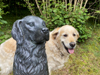
" Scotland - 4 - Time out to Torridon " Date & start time: 12th July 2023. Location of Start : Creag Mhor our 'Bed and Breakfast' at Balnain, Scotland, Uk. ( NH 456 304). Places visited : Lochcarron, Bealach na Bà, Applecross, Sheildaig, Acnasheen, Beauly. Walk details : Local walks only, most of the day driving. Highest point : Visiting old haunts. Walked with : Loes and the dogs, Dylan and Dougal. Weather : Overcast but generally dry, light rain to start, then clearing.
|
© Crown copyright. All rights reserved. Licence number PU 100034184. |

|
The formal Retriever Events organised today were not exactly relevant to us, but the Scottish countryside was and it was only a morning drive west from the top of the Great Glen to reach the west coast of Scotland. Loes loved Torridon, I fancied revisiting Applecross and Toscaig, which would give us some interesting countryside along the way. On the return we could make it a round trip by driving the coast road round from Applecross to Sheildaig, a real bonus.
We set off north with some wet looking skies above us but once past Beauly and Muir of Ord the road turned west and we were heading into slightly clearer weather,
Achnasheen owes its origins to the road junction where the road to Loch Maree and Poolewe turns off to the north. The main road and the train line continue on, gradually curving south once more towards the Kyle of Lochalsh and Skye.
At the head of the sea loch we reach Lochcarron, which has a delightful ribbon of houses along its northern shoreline.
We are hoping to get to Applecross for lunch. The road there has to negotiate the 'Bealach Na Bà' mountain pass that climbs between the hills further down the loch. The first surprise of the day was the fact that the Lochcarron Shipyards seem to be up and running once more, servicing huge oil rigs.
The Bealach or "Pass of the Cattle" was the old drovers route from the coastal areas of Applecross to the local cattle markets. It climbs from sea level to a height of 2053 feet . . . and comes with its own driving warnings !
However the road is a classic mountain pass and part of the 'North Coast 500 Road Tour' of Northern Scotland. As such is visited by tourists from all over, whether they travel by bike, car or smaller camper van. It seems that adding your country sticker is the thing to do . . . goodness knows what the old sign said !
We head up the pass, stopping at a layby to read the information board.
This is a single track road, so it is courtesy to wait at passing places for approaching traffic to clear.
Up the first steep climb, leaving the oil rig far below. Above that, the road enters a hanging valley and we have a gentler climb up the pass.
Not for long as the steep head of the valley is reached. Here the road does a series of spectacular hairpin bends to finish the final climb.
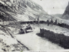
This was the road a few years back !
. . . when it was a real achievement to drive the pass by car. ( photos courtesy of Applecross petrol station )
Nowadays with modern vehicles the task is much easier and we reach the top all too quickly. We stopped, as many did, at the highest point to admire the view west toward The Isles of Raasay and Skye.
We've reached Applecross Village, 2053 feet down the other side and back to sea level. [ Should you want some, the petrol station offers 24 hour self service using a card machine and the petrol was a remarkably sensibly price.]
On the edge of the bay an adventure company offers kayak outings for beginners and experienced canoeists.
The Applecross Inn on Shore Street was sadly closed Tuesday and today (Wednesday morning) till 3pm so no lunch here. To be fair, we'd seen the notice back at Loch Carron to that effect, so were not caught out.
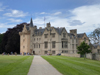
We still needed somewhere for lunch so we drove the short distance to Applecross House as I'd had a really nice meal there a few years back . . . and they were open today.
They serve meals in their Walled Garden Cafe and Restaurant
Fresh local produce . . . a seafood salad and what turned out to be a superb lunch.
We had a delightful walk around the grounds and in the woodland outside the walls afterwards, which included a glimpse of the old ice house and their deer herd in the paddock on the way out. - - - o o o - - -
Time was on our side so I wanted to take Loes "along the Street" and down the coast road to Toscaig.
Down through the village of Camusteel to the harbour at Camusterrach.
At the head of Culduie inlet is an abandoned boat that might have served the local villages especially in transporting bulk supplies or in winter when the pass was closed.
At the top of the hill looking down on Toscaig is a beautiful round house. It is a new-build by the owners of the house hidden behind, and Ann and I and the kids stayed in it on our holiday here in 2016
The end of the road . . . the Harbour at Toscaig. This is the closest road and best harbour for coastal supplied from The Kyle, but the photo doesn't do it justice, sorry.
Heading back north now to Applecross.
However our needs were few today . . . but it didn't stop us calling in for an ice cream !
Back past the shallow Loch a Mhuilinn and to Applecross Bay once again. It's gone 3pm and the pub was already busy with visitors as we passed, but having been recently refreshed, we continued on our way.
Taking the "new" road to Sheildaig via the small coastal villages of Fearnmore and Fearnbeg. When I first came here with my parents the road was only a pony track and I remember this wide road being built.
It probably existed as a rough track to these buildings on the An Cruinn Leum headland, next to a rather nice sandy bay. I believe this is or was a Naval Lookout, as the sheltered waters between here and Raasay were used for measuring the speeds of new boats. The "measured mile" could be observed in full and the boat or submarines could be 'calibrated' on test sailings.
The sun is out and the hills of Torridon are looking as good as we remember them. This is now a busy road, in the old days it would have been no more than a pony track for the postman and clergy who's jobs it was to serve these remote crofts and villages.
A classic red-roofed cottage with a view up the Torridon inlet . . . taken from the car as we drove by. The prominent hill above the cottage is Ben Sheildaig.
The island of Eilean Mòr, looking across to the hills of Beinn Bhreac, Ben Alligin and distant Baosbheinn.
The village of Sheildaig spread along the foreshore at the head of Loch Sheildaig.
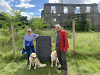
It is basically one house wide and includes shops, a pub and hotel. On the high ground above the village is a large camping and caravan site and a war memorial (behind which I once kissed a girlfriend !)
A small inlet beyond the village opens once more into the wider sea loch of Upper Loch Torridon. We stopped at a parking area to look across to Ben Alligin.
The layby also allows extensive views west down the loch towards the sea and the misty Cuillins of Skye.
Wild country with few roads on the other side of the loch.
Looking inland, the other rugged hill is that if Liathach, showing it's less dramatic side.
Heading east now and we pass into the Beinn Eighe Country Park and see the mountain famed for its white quartzite summit.
Looking back shortly afterward I found that classic view of Liathach that I had been searching for.
Sunshine and showers seems to be the order of the day now as we head up the Torridon (river) Valley towards Kinlochewe.
You've just got to do it . . . turn left at the village for a short diversion down the road to Loch Maree, where we get a fine view of Slioch Mountain across the waters of this twelve mile long, fresh water loch.
On past the waters of Loch a Chroisg, heading through the hills of Wester Ross, back to Achnasheen.
A damp journey for the last part of the day as we return once more via the towns of Muir of Ord and Beauly Our booking at the B&B has ended so its off to Drumnadrochit Hotel for tonight. - - - o o o - - - |
||||||||||||


Technical note: Pictures taken with my iPhone 11 pro phone camera.
Resized in Photoshop, and built up on a Dreamweaver web builder.
This site best viewed with . . . a return visit to familiar places.
Go to Home Page . . . © RmH . . . Email me here
Previous walk - 11th July - 3. Urquhart, Plodda & Tea
A previous time up here - 16th to 26th September 2016 - Applecross and Gairloch
Next walk - 13th July - 5. The Big Picture and Home
|
|
|
|
|
 |